52 Ancestors: An Address with a Story
Today, a bustling commercial street and a quiet, mostly empty park in Michigan stands where my ancestors lived for generations. In 1835, Toussaint Drouillard was granted just over 76 acres in what is now the Detroit area of Michigan — land he had been on for years already, but shifting borders and ownership of the area meant he had to re-affirm it was his.
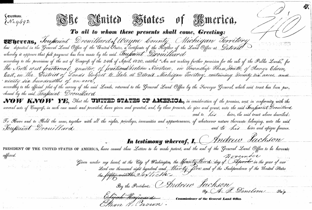
Toussaint Drouillard’s land grant signed by President Andrew Jackson.
It wasn’t easy to locate the correct site of the Drouillard property I was looking for, in part because the area was home to many Drouillards. When my 2x great grandfather Peter Francis (also sometimes Pierre Francois) Drouillard died in 1947, his obituary in the Ecorse Enterprise stated that he died in the home where he was born, at 1130 Goddard Road in Lincoln Park, Michigan. It went on to say “A retired farmer, he had lived at the Drouillard homestead throughout his life. Located at Fort and Goddard, the homestead had belonged to his father, one of the early settlers in Ecorse township.” Peter’s father was also a Pierre Francois Drouillard who went by Peter, but he was born in 1834. Pierre’s father was Toussaint Drouillard, the original settler of this land. Toussaint died in 1870, and his probate file was a rich source of information about the family.
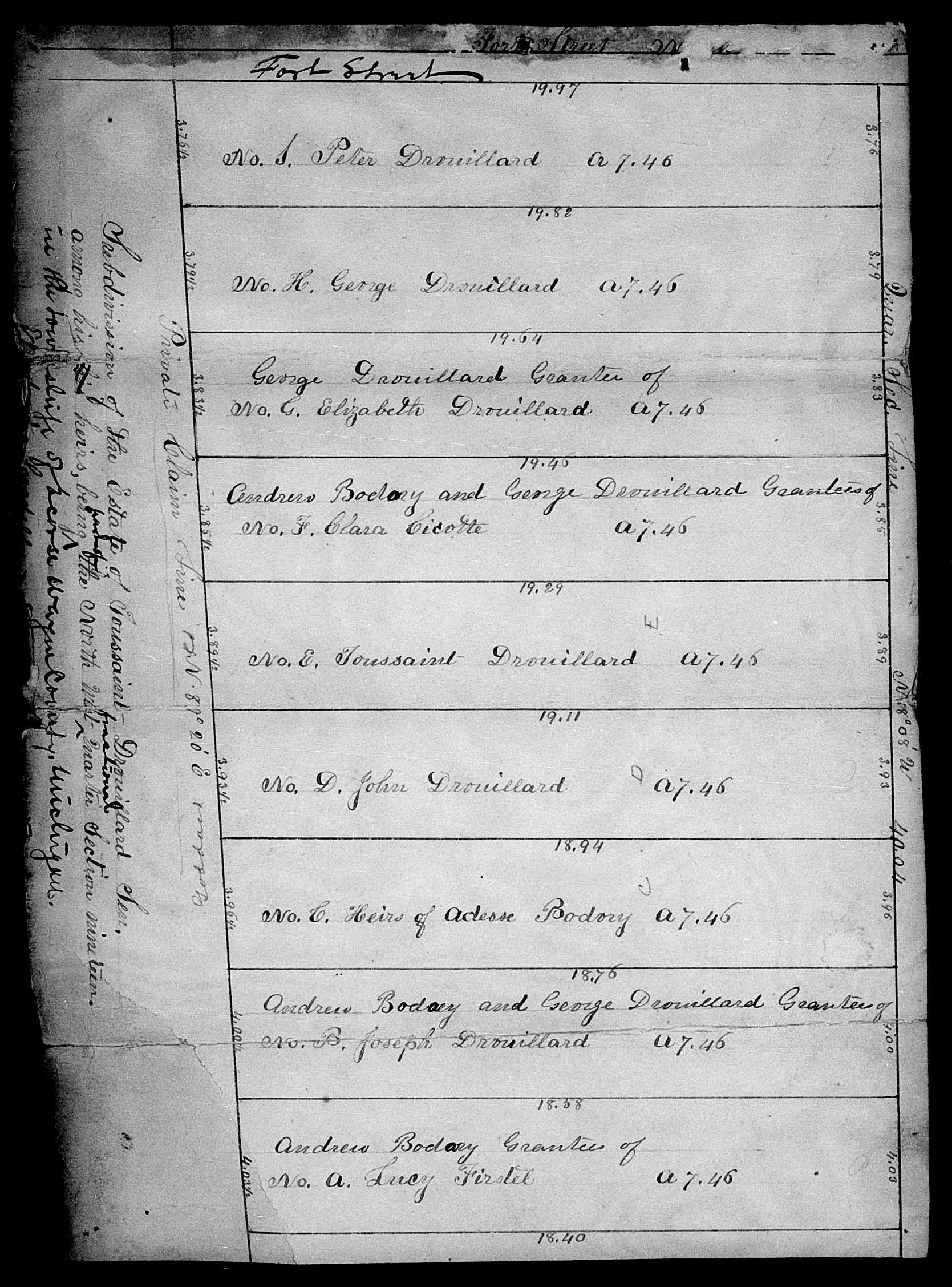
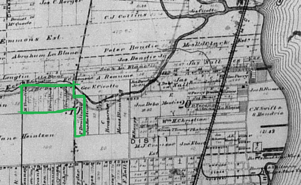
Toussaint Drouillard’s probate file includes this map dividing up the land in his estate
The information in Toussaint’s probate record includes that his son George could read and write and was named executor, while Peter was heavily involved in the estate process but could not read or write. Toussaint’s will gave his entire estate first and foremost to his widow Therese with the caveat that upon her death, it should be given to all his children to be divided among them. Therese died in 1879, and the couple’s children in birth order were Adesse (Drouillard) Bodary, Joseph Drouillard, Tousaint Drouilard, Peter Drouillard, John Drouillard, Elizabeth (Drouillard) Delosh, Clerene (Drouillard) Cicotte, Lucy (Drouillard) Ferstel, and George Drouillard. Adesse died just a few months before her mother, and it seems George obtained the interest of her children and some of his sisters in the land along with the children’s guardian Andrew Bodary. In the probate record, the land is described as “the north west fractional quarter of fractional section number nineteen in township three south of range eleven east… containing seventy six acres and ninety six hundredths of an acre.” However, at other points it was described as 67 or 63 acres, so it’s unclear exactly how this land was divided, and George Drouillard ultimately kept 1/3 of the land himself after being granted a portion from some siblings or their heirs. Peter Drouillard was granted 1/9 of the land.
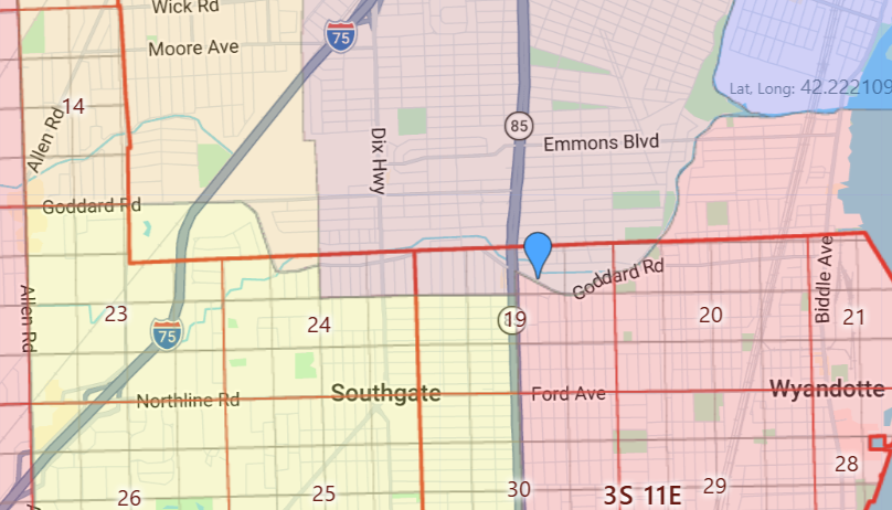
Section 19, Township 3 South, Range 11 East as mapped using GoogleMaps on RandyMajors.org.
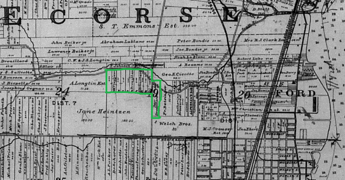
Using the location as traced above, I headed over to my favorite place (the Wisconsin Historical Society’s Library and Archives) and took a look at some Wayne County, Michigan plat books on microfilm. I wanted to understand how the ownership of the land had evolved. I’m so glad I did, because it appears that Peter Drouillard’s land was a little apart from his siblings’.
Wayne County Atlas, 1893, close up on Ecorse, Michigan, and the land of the Drouillard family. From microfilm held at Wisconsin Historical Society.
Wayne County Atlas, 1904, close up on Ecorse, Michigan, and the land of the Drouillard family. From microfilm held at Wisconsin Historical Society.
In modern Michigan, you will find a very small, one block long, name misspelled on the sign Drouillard Street right around the end of the first lot that’s on the other side of Fort here and across Fort, you can see through the way the roads run, an approximate shape of Peter Drouillard’s land. All of this aligns with the address given in the second Peter Drouillard’s obituary in 1947, 1130 Goddard Rd.
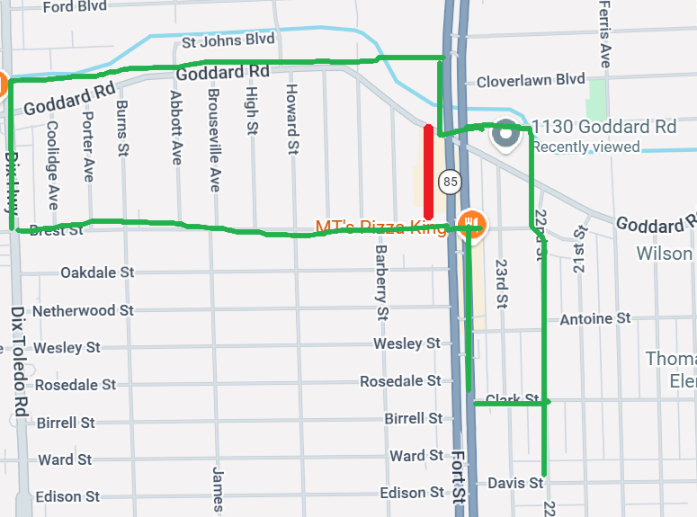
GoogleMaps image of the area today with the Drouillard land in green and the red indicating where today’s Drouillard Rd. is.
It’s not totally clear to me yet just how the land that Peter Drouillard lived on became his, as it does seem outside of what was indicated on the map from the probate file for his grandfather. It’s possible that the elder Peter Drouillard purchased a different plot right next to the land he received from his father, on the other side of Fort St. Based on the probate map, Peter Drouillard, son of Toussaint, would have owned the land around where the current Drouillard St. is. Between the 1879 probate map and the 1893 and 1904 plat maps, certainly that land did primarily remain in the hands of the Drouillard family. Further digging is required, but what I do know is that my family’s roots go deep here, both at 1130 Goddard and the farm that used to run along Fort St. and the land of Toussaint Drouillard.
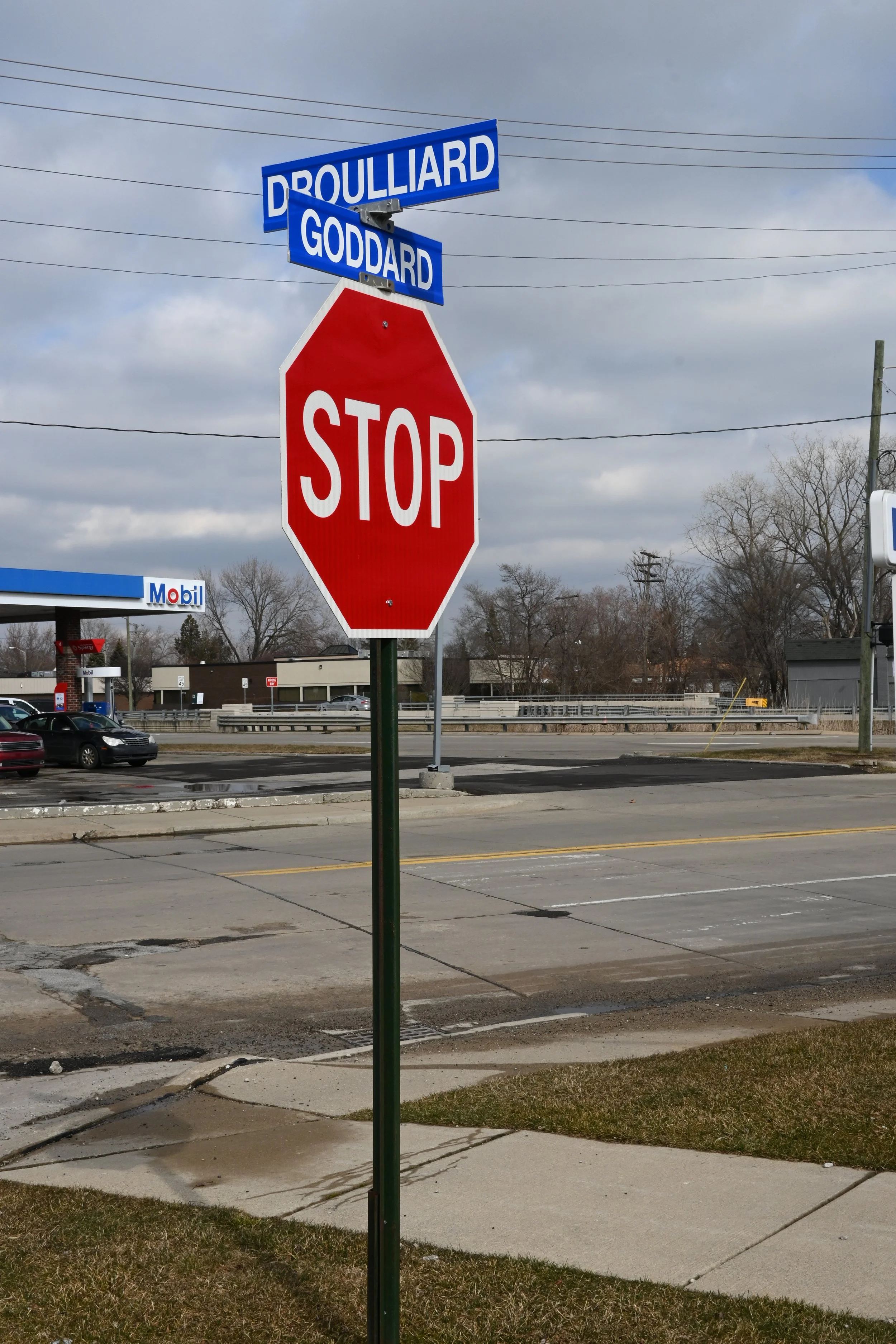
The corner of Drouillard St. and Goddard Rd. standing on the land that Pierre Drouillard the elder inherited from his father Toussaint, facing the land that Peter Drouillard was born on, farmed, and died on at 1130 Goddard, across Fort St. Taken by author in December 2022. And yes, I do know the street sign is misspelled. Maps have the right spelling!